Stonehenge is probably the most impressive megalithic monument. It had inspired people for millennia. Every society has had their own beliefs about it. First of all, to place Stonehenge in the context of British prehistory, here is the history of Britain up to the Bronze Age, when most of the construction of Stonehenge took place.
The Paleolithic Period 30,000 B. C. - 9000 B. C.
During the "Great Ice Age", which is thought to have lasted about a million years, there were many periods of tens of thousands of years when the ice-cap which covered Britain melted away, and the climate became as warm as it is today. In these interglacial periods Homo erectus or other human ancestors first came to Britain as hunters and food gatherers. They were merely large families or small clans, scattered widely over the southern half of Britain. During this period, the Paleolithic, or Old Stone Age, Britain still formed, as least at times, a part of the Continent, Each time the climate worsened and ice caps began to form in the hills, the animals and their human predators moved south.
For most of the period the only archaeological evidence we have consists of the implements made by chipping flint nodules or flakes to the required shapes. Homo sapien sapiens evolved about 100,000 years ago, and is known to have existed in Western Europe during the last 30,000 years, During the later cold spells of the Ice Age, their skills enabled them to clothe themselves with animal skins, and to hunt in the areas round the edges of the ice.
In Britain there are a few caves, like those in Cheddar Gorge, Somerset, where family groups found conditions suitable for survival, In some of these the debris of food bones and broken implements later became sealed by a layer of stalagmite, which has preserved many objects that would otherwise have decayed; so implements of bone survive as well as of flint.
The Mesolithic Period 9000 - 5000 B. C.
A rise in the sea-level, brought about largely by the melting ice-cap, cut Britain off from the Continent about 9000 years ago. Ireland had been isolated earlier.
A steady improvement in the climate allowed the population to increase somewhat; but as long as people had to rely on hunting and gathering instead of agriculture, their numbers could never grow large.
The improvement of climate was accompanied by a slow spread of forest from the South, leading to changes in animal life. the cold-weather herds of the steppes disappeared, to be replaced by forest animals, and there was also an increase in the species of fish. This led to changes of diet and modifications of the old hunting methods.
Of the people themselves of this period we know very little. All we have are some flint and bone implements. Though many of the occupation sites are known, and have in varying degree been excavated, there are no structural remains.
The Neolithic Period 5000 - 2700 B. C.
Shortly before 3000 BC the first parties of farmer immigrants established themselves in the chalk Down country of southern Britain, From early beginnings in the Near East, the twin activities of grain cultivation and stock raring had spread slowly westwards. The visible monuments of this cultural advance are of three kinds- flint mine, such as Grime's Graves, Norfolk, causewayed camps, such as Windmill Hill, Wiltshire, and long barrows or long cairns, such as West Kennet, Wiltshire.
A more regular food supply led to a steady increase of population, which was further increased by the arrival of new settlers and improved farming techniques. During this period, Britain was occupied by many tribes of different cultural levels, probably speaking different languages.
The need for open land for agriculture meant that trees had to be felled, On the chalk Downs the woodland was comparatively light and dry, and clearing could be done partly by burning and partly be felling. Cutting down trees needed axes, and for these igneous rocks were at first used, Some centuries later, seams of fine flint deep in the chalk were mined.
Causewayed camps, marked by bank-and-ditch rings around hill-tops, have been recognized on a number of sites; the ditches have many causeways for crossing, which correspond with openings in the banks, In this way they can be clearly disguised from the hill-forest of the Iron Age. They may have been meeting-places for formal communal purpose and perhaps markets.
The most important monuments are undoubtedly the burial sites, These are called megalithic as the burial-chambers and approach passages are of large stone slabs. In certain areas, where suitable slabs were not available, drystone walling was used.
Broadly the tombs fall into two main groups which were passage graves, with a passage from the entrance to a circular burial chamber, and gallery graves, with a long rectangular chamber, the whole of which was used for burials. Some of these have transepts or side-chambers, as in the Cotswold-Severn group. When complete, these structures were concealed below long mounds, although few are roughly circular, and contained by stone walling. The long ones were usually higher at the entrance end, and there was often a forecourt, where rites were performed when the tomb was opened for a burial, after which the entrance and forecourt were again masked by carefully built stone blocking.
In parts of southern and eastern England, long mounds of similar age are to be found, entirely lacking the internal stone structures. Excavation has revealed that similar turf and timber structures were often present.
The Bronze Age 2700 - 700 B. C.
The division of prehistoric cultures into Stone Age, Bronze Age and Iron Age is a useful time-scale based on the technological skills employed in making important tools and weapons; no hard and fast line can be drawn. The first newcomer to Britain with a small metal knife-dagger began the Bronze Age, but the essentially Neolithic way of life, for most people, was not in the least changed, and it was only slowly that the new metal objects spread to all parts of the island.
The new immigrant group coming in from the Low Countries has been called the Beaker People, because of the drinking vessels found in of their tombs. They also brought with them the custom of individuals burials, under round barrows, much smaller than the large, collective long barrows.
The round barrow slowly became the normal tomb of the Bronze Age, although after a time cremation replaced burial. The commonest visible monuments of the Bronze Age are the many thousand of these round barrows, mainly in Dorset and Wiltshire. A few still stand at about their original height, but most have been reduced, often by later agricultural activity, and an unknown number have been completely destroyed ploughed flat in the last 2000 years.
In chalk country, houses of this period can be found only be excavation, and show a s a pattern of post-holes. In the West Country, especially on Dartmoor, such as in the Chagford area, where huts were built of stone, settlements of this date may still be seen. The boundaries of Bronze Age corn plot are sometimes visible as slightly raised banks, known as lynchets.
The Beaker People date from about 2300 B. C., and is typified by the pottery. The Wessex culture dates from about 1700 B. C., and is typified by rich burial mounds, and large amounts of artifacts in graves. The Deverel-Rimbury culture dates from about 1400 B. C., and is typified by pottery and settlement sites.
date BC         period / culture   metals used               main artifacts

Early Bronze Age

2700-2100       early beaker      (Ire) copper + arsenic      flat axes, halberds

                                         (UK:)copper + tin

2100-1900      late beaker       same                          knives, Bush barrow, tanged spearheads

1900-1500       urn              (Ire And UK:) copper + tin

Middle Bronze Age

1500-1300                          copper, tin                 palstaves, socketed spearheads

1300-1200                                                           rapiers

1200-1000          early urnfield

Late Bronze Age

1000-900           late urnfield                          socketed axes, palstaves

900-700                                                     leaf-shaped swords ("Ewart")
Around 700 B. C., the Celts invaded Britain and started the Iron Age. Agricultural lands became very valuable and thus it was a time of great warfare. It has been called the Age of Hillforts. The most obvious monuments dating from the Iron Age are earthwork hillforts such as Maiden Castle, and figures etched into the ground exposing the underlying chalk, such as the Cerne Giant and Uffington Horse. There is some evidence that the Cerne Giant was intended to represent Hercules, and thus might date from the Roman period, although obviously made by the local Celts. In 55 B. C. and 54 B. C., Julius Caesar invaded Britain but was unable to conquer it. In 43 A. D., Emperor Claudius approved the invasion of Britain. Aulus Plautius was assigned to be the commander of the expedition. The Romans successfully took over England, and started Roman Britain. Rome fell around 400 A. D., those in Britain were left to fend for themselves. They sustained waves of immigration from Angles, Saxons, and Jutes. Thus started Anglo-Saxon England. William the Conqueror invaded Britain in 1066, and started Norman England.The Bronze age is often called the Age of Megaliths because it was common for people at the time to erect stone monuments for religious purposes. A single standing stone all by itself is called a merhir. In Ireland, they had burial mounds containing stones. They stones still remain and often take the form of a large stone on top of three other stones. A monument of this type is called a dolman. Another type of stone monument is a stone with a hole in it. The most famous example is the Man-a-Tol in Cornwall. Newgrange is a famous Neolithic passage grave in Ireland dating from 3000 B. C. Carnac, in France, is a large number of stones lined up in parallel lines.
In Britain, stone circles were most popular. There are currently about 900 stone circles in Britain that date from the Neolithic or Bronze Age. Scholars estimate that about twice that many originally existed. Scholars classify stone circles into the following categories:
1. Circle-Henge - stone circle surrounded by a ditch, such as Mayburgh in Westmoreland
2. Center Stone - stone circle with a stone in the center, such as Boscawen Un in Cornwall
3. Multiple - rings of stones within rings of stones, such as Shovel Down in Devon
4. Pairs - two stone circles near each other, such as Burn Moor in Cumberland
5. Triples - three stone circles near each other, such as Drizzlecomb in Devon
6. Ovals - such as Achany in the highlands of Scotland
7. Recumbents - groups of circles associated with a burial, such as Cairnfauld in Grampion, Scotland
8. Circles - such as Ardblar in Powys, Wales
9. Clava Type - such as Aviemoe in the highlands of Scotland
10. Embanked - such as Grassington in Yorkshire
11. Four-Poster - stone circle with only four stones, such as the Druid’s Altar in Yorkshire
12. Horseshoe - such as Achavanich in Scotland
13. Kerb-Circle - low stones, long and narrow, laying down on the ground, such as Little Meg in Cumberland
Here is data on some of the stone circles in Britain.
name                        location                         diameter (meters)   original number of stones

Aberscross               Highlands, Scotland                7.6

Achavanich              Broubster, Scotland                42.7


Arbor Low 3              Derbyshire, England

Ardblair                 Tayside, Scotland                   14.8                  6

Avebury                  Wiltshire, England                  425

Banc Du                  Powys, Wales                        18

Blakeley Raise           Cumberland, England               16.7                     11

Blakey Topping           Yorkshire, England                  16

Boskednan                Cornwall, England                  21.8                    22

Brisworthy               Devon, England                     24.8                    42

Broomrigg Plantation 3   Cumberland, England                16.8

Broomrigg Plantation 4   Cumberland, England                55

Bryn Gwyn Stones         Anglesey, Wales                    12

Casterton                Westmorland, England               19

Castlerigg               Cumberland, England                32.6                 42

Cauldside Burn       Dumfries and Galloway, Scotland        25                   20

Cerrig Gaerau ESW       Powys, Wales

Cerrig Gaerau WSW       Powys, Wales                        21

Cnoc Ceann A'Gharaidh Outer Hebrides, Scotland              21.6

Craddock Moor          Cornwall, England

Croft Moraig           Tayside, Scotland                    12                  12

Drannandow             Dumfries and Galloway, Scotland      27.2                13

Druid's Circle         Gwynedd, Wales                        4                   5

Druid's Seat           Tayside, Scotland                     8.5                12

Duddo Five Stones  Northumberland, England                   9.8                 5

Duloe                  Cornwall, England                    12                   8

Elva Plain             Cumberland, England                  34.4                30

Fernacre                Cornwall, England                   46                  70

Fernacre - North West Cornwall, England

Fernworthy              Devon, England                     19.8                 27

Ffridd Newydd - North   Gwynedd, Wales                     33

Ffridd Newydd - South   Gwynedd, Wales                     51                   45

Fortingall - NE Circle  Tayside, Scotland                  8.2

Fowlis Wester East      Tayside, Scotland                  8.2                  12

Fowlis Wester West      Tayside, Scotland                  6.7

Girdle Stanes         Dumfries and Galloway, Scotland     39                    45

Goodaver               Cornwall, England                  32.3                 28

Gors Fawr              Dyfed, Wales                       22.3

Greenland              Tayside, Scotland                   8.5                  9

Grey Yauds             Cumberland,  England               47.6                  88

Guidebest              Scotland                           57.3                  13

Haltadans              Shetland, Scotland                 11.3                  22

Harestanes             Borders, Scotland                   3                     5

Hoarstones             Shropshire,  England               23.3

Hough                Tiree, Inner Hebrides, Scotland      40                    12

Hurlers -North        Cornwall,  England                  34.8                  28

Hurlers - South       Cornwall, England                                         26

Innesmill             Grampian, Scotland                  33.5                  12

Lacra 1               Cumberland, England                 16.2                   6

Lacra 2               Cumberland, England                 15                    11

Lamlash               Arran, Scotland                     6.7                    7

Learable Hill         Highlands, Scotland                 17

Leaze                 Cornwall, England                   25                    28

Llyn Eiddew Bach III  Gwynedd, Wales                      12.8                  14

Loch Buie             Mull, Inner Hebrides, Scotland      13.3

Loupin' Stanes - Central  Dumfries and Galloway,  Scotland  11.4                12

Loupin' Stanes - North West Dumfries and Galloway, Scotland 13.4

Machrie Moor 1         Arran, Scotland                    14.6                  12

Machrie Moor 2         Arran, Scotland                    12.8

Machrie Moor 3         Arran, Scotland                    16.3                   9

Machrie Moor 4         Arran, Scotland                     9                     5

Merry Maidens          Cornwall, England                   23.8                 19

Mosley Height          Lancashire, England                 12.8                 18

Murthly                Tayside, Scotland                    9.9                  8

Nant Tarw -ESE         Powys, Wales                        20.7

Nant Tarw -WNW         Powys, Wales                        19.2

Nine Stone Close       Derbyshire, England                 13.7                  9

Nine Stones            Cornwall, England                   15.2                  9

Nine Stones            Devon, England                      7.8                  40

Parkneuk               Tayside, Scotland                  13.7

Porlock                Somerset,  England                 24.4                  45

Rhos Y Beddau          Powys, Wales                      12.8

Rollright Stones       Oxfordshire, England              31.7                   80

Scorhill               Devon, England                    26.8                   65

Sherberton             Devon, England                    29.9                    7

Shethin                Grampian, Scotland                5.1                    20

Simonburn              Northumberland, England           8.9                    11

Six Stones             Powys, Wales                      24.4                   14

Stall Moor             Devon,  England

Stannon                Cornwall, England                  43

Strontoiller           Strathcylde, Scotland             19.8                   35

Swinside               Cumberland, England               28.6                   60

Temple Wood            North  Strathcylde, Scotland      10.5

Trippet Stones         Cornwall, England                 32.9                   28

White Moor Down        Devon, England                    20                     18

Whitehall Wood         Grampian,  Scotland                8.2

Withypool              Somerset, England                 36.4                  100

Ynys-Hir               Powys, Wales                      18
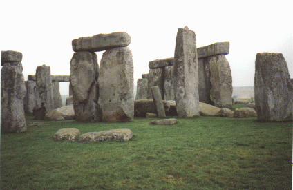
Probably the second most famous stone circle is Avebury which is the largest stone circle in Britain. Avebury is in the Kennet district in Wiltshire, and has a diameter of 1,400 feet. Avebury is the best preserved superhenge in Britain, consisting of a huge earthwork that encloses the great circle of about 100 megaliths, and two further rings of about 30 stones each. Both of these rings contained other standing stones: the northern, three enormous megaliths on the sides of a square known as the Cove, two survive, and Avebury’s tallest megalith, the Obelisk, destroyed in the 18th century, in the southern. None of these three rings is perfectly circular. The largest is the least regular, as it follows the inner lip of the great ditch. Unfortunately, most of the stones at Avebury were deliberately torn down by the medieval church which condemned it as a pagan monument. The most famous stone circle, of course, is Stonehenge, which is the only stone circle that has stones on top of other stones. It was a remarkable feat of primitive engineering.
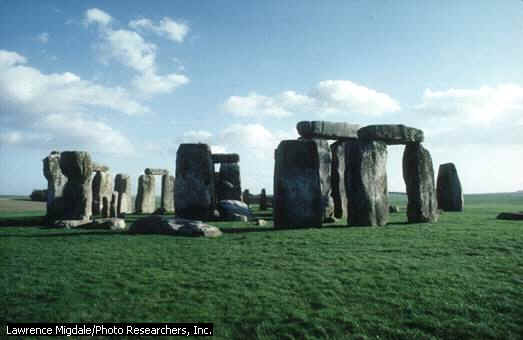
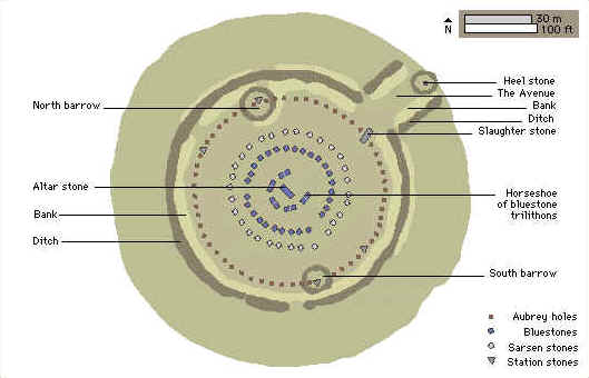
The megalithic ruin known as Stonehenge stands on the open downland of Salisbury Plain 2 miles west of the town of Amesbury, Wiltshire, in Southern England. Stonehenge consists of four concentric ranges of stones. The outermost range is a circle, 100 ft. in diameter, of large, linteled, sandstone blocks called sarsen stones. Within this circle is a circle of smaller blue stones consisting mainly of spotted dolerite, with four specimens each of rhyolite and of volcanic ash. The latter circle enclosed a horseshoe-shaped arrangement of five linteled pairs of large sarsen stones. Within this arrangement is a smaller horseshoe-shaped range of blue stones enclosing a slab of micaceous sandstone known as the Altar Stone. Near the entrance to the avenue lies the so-called Slaughter Stone, a sarsen stone that may originally have stood upright.
Grouped around the main structure are a number of barrows, some of which contain chips of a blue stone similar to that found in the concentric ranges. The blue stones are from the north flank of the Prescelly Mountains in Wales. The Altar Stone is believed to have come from the region near Milford Haven, Pembrokeshire.
Stonehenge is surrounded by a circular ditch, 340 ft., in diameter and 5 ft deep, within which is a bank and a ring of 56 pits called the Aubrey holes. At the northeast end a break in the ditch affords access to a ditch-bordered avenue that extends in a generally northeastward direction to the East Avon River. The avenue is 75 ft wide and nearly 2 miles long.
8000 B. C. - Totem Poles
Hunter-gatherers of the Mesolithic period erected three huge pine posts in the great pine forest that covered the site at the time. The 1960's car park is built over these - the large round discs you can see in the car park are the modern markers for these 10,000 year old holes.
Stonehenge I (3100 - 2700 B. C.)
The earliest portion of the complex, which dates to approximately 3100-2300 B. C., comprised a circular bank-and-ditch of about 330 feet in diameter. Just inside the earth bank were a circle of the 56 "Aubrey holes", now invisible on the surface. The holes may have originally held wooden posts.
Stonehenge II (2700 - 2500 B. C.)
A large number of wooden posts were on the site during this time. These may have guided people through narrow paths to the ceremonial center, adding a mystique to the entry. There was a large number of posts but they may not have been all up at the same time. It is possible to make out the outline of perhaps a round structure in the center of the circle, and there does appear to be a passageway leading out from the southern entrance.
Stonehenge IIIa (2500 - 2400 B. C.)
The first stones brought to the site are the bluestones, imported all the way from Wales. Probably dating to this time also the four "Station Stones", only two of which survive, and on the north-east side, an earthwork Avenue which runs from the break in the bank-and-ditch was added. The now-fallen "Slaughter Stone", located at the break in the bank-and-ditch may date from this period, as may also the "Heel Stone", located further out along the Avenue.
This double horseshoe of bluestones arranged in pairs is an enigmatic period of Stonehenge. It was short-lived, even though it must have taken a phenomenal amount of work to raise.
Stonehenge IIIb (2400 - 2200 B. C.)
The blue stones were taken down, and the massive sarsen stones were raised. This is the only stone circle with stones raised on top of other stones. There was an outer circle of linteled sarsen stones enclosing a horseshoe of linteled sarsen stones. Also, during this time, there was a man buried on the ditch which had since mostly silted up.
Stonehenge IIIc (2200 - 1800 B. C.)
The bluestones were returned to the site. They were placed in a circle within the sarsen circle, and then a horseshoe within the sarsen horseshoe. Stonehenge takes its familiar appearance. After this stage, two concentric circles of pits were dug outside the sarsen circle, the Y and Z holes, thirty of each lining up with the sarsens. They are imprecisely marked out, and stones were never placed in these holes, though we can imagine that another two rings of stones outside the sarsens was planned. Whatever the plans, this stage was never implemented.
1100 B. C. - The Avenue is lengthened for another 1 1/2 miles out to the river Avon at Amesbury.
43 A. D. - 410 A. D.
Stonehenge was desecrated by the Romans, who tore down a number of the upright stones.
650 - 690 A. D. - A man was executed and buried at Stonehenge.
1130 - Henry of Huntingdon wrote "Stanenges, where stones of wonderful size have been erected after the manner of doorway, so that doorway appears to have been raised upon doorway; and no one can conceive how such great stones have been raised aloft, or why they were built there".
1663 - John Aubrey did the first known systematic inspection of the site. He attributed the construction to the Druids who used the site as a temple.
1740 - Dr. William Stuckly, also a proponent of the Druid theory, investigated and measured the site, and was the first to suggest that it was astronomically aligned.
January 1797 - Two uprights and a lintel west of the Altar Stone fell down.
1900 - Two other stones, an upright and its lintel fell down.
1901 - Stonehenge is fenced off and an entrance fee charged to visit the site.
1923 - The remains of the man executed in the 7th Century were discovered.
1953 - On some of the fallen stones, shallow carvings were found depicting bronze axheads of a type used in Britain during 1600 - 1400 B. C.
1958 - The five stones that fell in 1797 and 1900 were raised, giving the monument the approximate appearance it had during the Roman occupation.
1977: Visitor numbers reach 800,000 per year.
July 1978: Department of the Environment restricts public access to Stonehenge, to limit erosion by visitors, then running at 2,000 per hour during the summer season.
1982: Visitor figures down to 500,000 per year.
1983: Visitor figures begin to rise again, reaching 600,000 per year.
November 1986: Stonehenge is designated a World Heritage Site.
1991: Paying visitors now number 700,000 per year.
June 1996: English Heritage and Intel launch the virtual reality model of Stonehenge on the Internet.
For comparison, construction ofthe Great Pyramid of Khufu at Giza began in 2467 B. C. and it was completed about 20 years later, around 2450 B. C.
The construction of Stonehenge was a staggering engineering feat of engineering, considering the primitive technology available, requiring enormous time and vast amounts of hard manual labor. In its first phase, Stonehenge was a large earthwork; a bank and ditch arrangement called a henge, constructed approximately 5,000 years ago. It is believed that the ditch was dug with tools made from the antlers of red deer and, possibly, wood. The underlying chalk was loosened with picks and shoveled with the shoulderblades of cattle. It was then loaded into baskets and carried away. Modern experiments have shown that these tools were more than equal to the great task of earth digging and moving.
About 2,000 B. C., the first stone circle, which is now the inner circle, comprised of small bluestones, was set up, but abandoned before completion. The stones used in that first circle are believed to be from the Prescelly Mountains, located roughly 240 miles away, at the southwestern tip of Wales. The bluestones weigh up to 4 tons each and about 80 stones were used, in all. Given the distance they had to travel, this would have been a tremendous transportation problem.
It is generally believed that the stones were dragged by roller and sledge from the inland mountains to the headwaters of Milford Haven. There they were loaded onto rafts, barges or boats and sailed along the south coast of Wales, then up the Rivers Avon and Frome to a point near present-day Frome in Somerset. From this point, the stones were hauled overland, again, to a place near Warminster in Wiltshire, approximately 6 miles away. From there, it's back into the pool for a slow float down the River Wylye to Salisbury, then up the Salisbury Avon to West Amesbury, leaving only a short 2 mile drag from West Amesbury to the Stonehenge site.
The giant sarsen stones, which form the outer circle, weigh as much as 50 tons each. To transport them from the Marlborough Downs, roughly 20 miles to the north, is a problem of even greater magnitude than that of moving the bluestones. Most of the way, the going is relatively easy, but at the steepest part of the route, at Redhorn Hill, modern work studies estimate that at least 600 men would have been needed just to get each stone past this obstacle.
Once on site, a sarsen stone was prepared to accommodate stone lintels along its top surface. It was then dragged until the end was over the opening of the hole. Great levers were inserted under the stone and it was raised until gravity made it slide into the hole. At this point, the stone stood on about a 30° angle from the ground. Ropes were attached to the top and teams of men pulled from the other side to raise it into the full upright position. It was secured by filling the hole at its base with small, round packing stones. At this point, the lintels were lowered into place and secured vertically by mortice and tenon joints and horizontally by tongue and groove joints.
Each group of people to have visited the site had their own theory as to who built Stonehenge. In medieval Europe, theories ranged from giants to Merlin to the Devil. Some people thought it was built by the Romans. From the 17th Century to the 19th Century, it was widely believed it was built by Druids, who were the priests of the Celts who dominated the region from around 700 B. C. until the Roman invasion in 43 A. D. In reality, Stonehenge was begun by the people of the late Neolithic period, around 3000 B. C., and carried forward by people from a new economy which was arising at this time. These new people, called Beaker People, because of their use of pottery drinking vessels, began to use metal implements and to live in a more communal fashion than their ancestors. They were immigrants from the continent.